 |
|
 |

|
|
|
| 05-03-2011, 08:11 PM | #1 |
|
Second Lieutenant
 116
Rep 212
Posts |
Gone South - Northern Olympic Peninsula Tour
Each year I do 4-5 driving trips when the weather warms up, usually lasting 2-3 days and about 800-1000km in length, exploring the driving routes in the region. Last year, I based my routes on the excellent book Destination Highways BC, and I will be repeating them this year
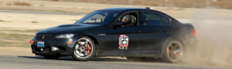
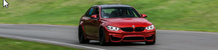
I usually start in mid-May and go until September, but this year we're having a warm spring so I was itching to get started. Unfortunately, if I want to head east into the mountains, some of the passes are still cold and slushy. Same issue if I want to head north. So, I was trading e-mails back and forth with a fellow club member wondering where to go. She mentioned 2 words that stuck to my head: "go south." Makes sense, but where to go? Cascade Mountain passes for the minor routes (as in, routes I'd want to take) are mostly closed until mid-May. No fun roads keep going south, just the drone of I-5. So, quick check of Google Maps, and I decided on going to the Olympic Peninsula. WA SR-112 looked promising, as it's built right on the cliff's edge overlooking Juan De Fuca Strait. There's also US-101 in WA, the northern tip of the famed Pacific Coast Hwy, that loops around the Olympic National Park. Here's the route:  Settled on a 1-day trip. 800km or 500mi, with 2 ferry trips. Decided not to stop on road sides as often for pictures as my previous trips, because I got a GoPro in-car now. Also, the schedule was tight due to the ferry schedule. Still, here's some.... Deception Pass Bridge, to Whidbey Island:         Stopped at a field on my way to Coupeville Ferry because I thought it looked an awful lot like the Windows XP default wallpaper :P       Then, Coupeville ferry terminal:        On the ferry:     Stopped at Port Angeles for fuel (last gas station on the route), but ran into a 100+ cars Mustang and Cougar meet. So, I stopped for some pictures while eating my packed lunch:    The red Ford GT with the WA license plate FORD GT has been making its way around various car meets for a couple of years; I've seen it on the photo threads of meets in the Seattle area... and now I've seen it for real      That's the Black Ball Ferry in the background, servicing Port Angeles and Victoria, BC, across the Strait on Vancouver Island.      More V8s than you can shake your fist at.... Good thing I drive one too :P Here's the end of the road, Neah Bay, probably the westernmost settlement in the continental US. You can see Vancouver Island across the Juan De Fuca Strait. BC Hwy 14 runs along that rugged coast; I've done it in June last year, and it was a great road as well.      Finally, back to Port Townsend for the ferry back onto the "right" side of Puget Sound....    On the ferry again....      Crossed the border into the US at around 8AM on that day. Got back to the border at 9PM. Here's some of the videos I took that day with the GoPro Hero HD 960, mounted off the sunroof. Overtaking on US-101 just past the SR-113 junction, heading east towards Port Angeles. I haz V8 rawr? WA SR-112 westbound, towards SR-113 junction. WA SR-112 westbound, towards Neah Bay. US-101 eastbound, towards Port Angeles and on the southern shore of Lake Crescent. Edit: Uploaded the final video, WA SR-112 eastbound from Neah Bay, basically the reverse of the 3rd video. Last edited by Veritable; 05-04-2011 at 12:29 AM.. |
| 05-03-2011, 10:54 PM | #2 |
|
Lieutenant Colonel
 
234
Rep 1,508
Posts |
I know many of these roads/sights. Very nice. Thanks for sharing!
__________________
 Current: 2016 F80 M3 6-Speed | SO | AB XT1 | ZCP | M Performance Suspension | GC Camber Plates Previous: 2009 E90 M3 |
|
Appreciate
0
|
| 05-04-2011, 01:36 AM | #6 |
|
Second Lieutenant

28
Rep 204
Posts
Drives: BMW M3 Coupe E92
Join Date: Jul 2010
Location: Munich / Germany
|
Beautiful. I wish i could drive my M3 in Canada und US.....
|
|
Appreciate
0
|
Post Reply |
| Bookmarks |
|
|


")